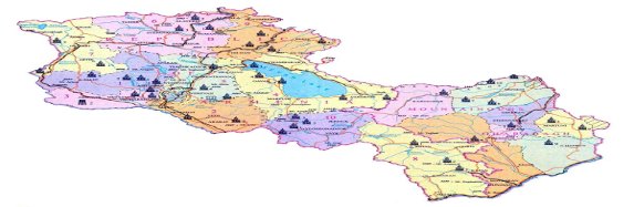
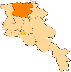
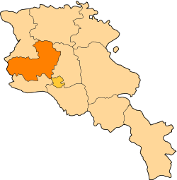
The Regions (Marzes) of the Republic of Armenia

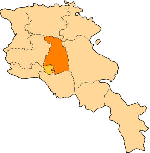
The Region of Tavush
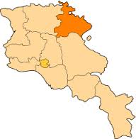
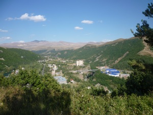
The Region of Tavush is located in the Northern part of Armenia. Tavush is the woodiest region of Armenia, almost half of its territory is covered by forests.
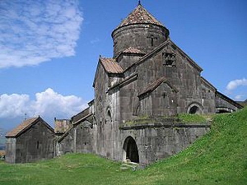
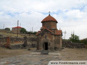
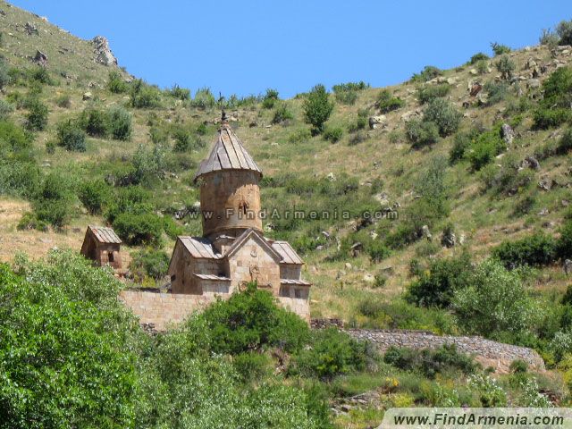
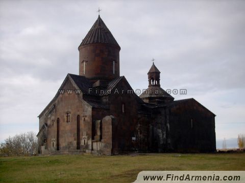
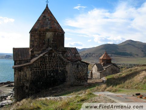
The woody region of Tavush gets a wonderful look especially during autumn. The most part of the region is 800-1700 m high above the sea level. There are a lot of animals in this region. Particularly you can see brown bears, wild boars, foxes, wolves and other wild animals. Here there nearly 40 species of birds. The town named Ijevan is the centre of this region. Due to the excavations carried out in this region, there were found tombs and castles of 2-1 centuries B.C. The castles, monastic complexes of this region are the proofs that people have inhabited this area from ancient times. One of the most prospering towns of Armenia is the town of Dilijan. This town has become a centre of Culture and Health. There are many hotels and health resorts here, where they cure diseases of lungs, liver, and illnesses of abdominal and stomach-intestinal zones, also disorders of digestion. There are nearly 20 sources of mineral water in the territories of Dilijan and Ijevan towns. The monastic complex of Goshavank (11-13th centuries), the monastic complex of Haghartsin (11-13th centuries) and other constructions have become the adornment of the Region of Tavush.
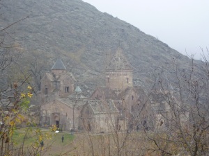
Goshvank monastry
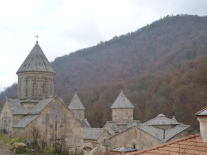
Haghartin monastery
and other buildings have become Tavush region’s adornments. Situated in high mountains hidden in the clouds, the monasteries have a charming beauty.
the material is taken from the http://www.findarmenia.com/arm/armenia/tavush
The Region of Lory
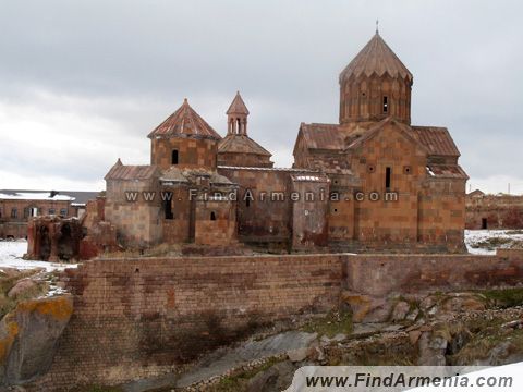
The Region of Lory is located in the North-Eastern part of Armenia, the town of Vanadzor is the centre of the region. The territory of the Region of Lory occupies half of the Eastern part of Gugark province of the historic Armenia. During the 10-11th centuries there existed here an independent Armenian state: the Kingdom of Lory. This region is rich especially in fruit-bearing trees, forests and fertile fields. The climate is moderate. The region has a rich culture since the ancient times. The famous sights of the region are the monastic complexes of Sanahin

and Haghpat
These two monastic complexes were built in this territory during the 10-13th centuries. In 1996 these two monastic complexes became the world heritage of UNESCO.
the material is taken from the http://www.findarmenia.com/arm/armenia/lori
The Region of Shirak

The Region of Shirak simultaneously borders two countries: Turkey and Georgia. The peculiarity of geographical location is that the territory of Georgia that is alongside the state border of the Region of Shirak is mainly inhabited with Armenians. The Region of Shirak got its name from the Shirak district of Ayrarat province of the historic Armenia, which occupied a larger territory. The region is rich in fertile soil, the climate is cool. It has a continental climate. Unlike other regions during the cold months in winter there are frostbites here and it is very hot during summer. According to Richter’s scale here is 8-9 points seism active zone. The centre of the region is the town of Gyumri. Gyumri is 1550 m high above the sea level. According to thearchaeologists, people have lived in Gyumri nearly one million years ago. Here there were found relics of elephants, bulls, camels and other unknown animals. The town of Artik is rich in tufa factories. There are tufas of 40 different colors in Armenia.Near the town of Artik there is the monastery of Harich, which was built during the 7-8th centuries
The monastic complex of Marmarashen is located on the left bank
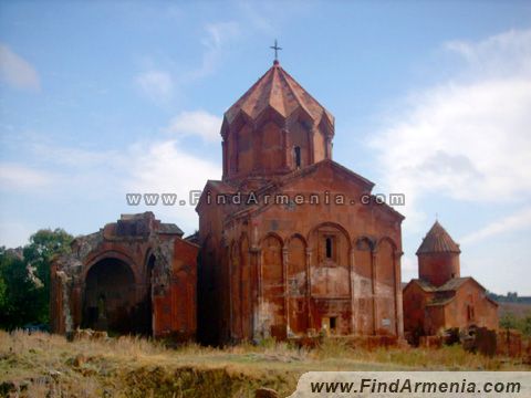
of the Akhuryan river. This region has been damaged a lot in the result of the earthquake of Spitak in 1988.
the material is taken from the http://www.findarmenia.com/arm/armenia/shirak
The Region of Aragatsotn
The Region of Aragastotn is located in the Eastern part of the Republic of Armenia. The town of Ashtarak is the centre of the region. The region borders with Turkey. The surface is 2753 sq. km, the population is 141.000. The important geographical peculiarity of the region is that it is located between the capital Yerevan and the highest mountain of RA Aragats.

The highest peak of Aragats mountain is 4096 m high above the sea level. Aragats has always been in the focus of attention of geologist tourists. The slopes of the mountain are covered with the civilization of the past. There are many picturesque places in this region. Here are the most interesting, charming churches of Tsiranavor (10-13th centuries),

Karmravor (7-19th centuries)
Spitakavor (13th century) churches.
The Church of Spitakavor
The old style of Karmravor church, the tile roof of the church is preserved up to our times. There is an astronomic centre in the Town of Byurakan, which is located on the slope of the Region of Aragatsotn. It is a powerful centre for Armenians, because it is known all over the world. The observatory of Byurakan was opened in 1946. The observatory is 1500 m high above the sea level. It is the biggest observatory of the world. The Castle of Amberd is 7 km far from Byurakan, in the Northern part of the region.
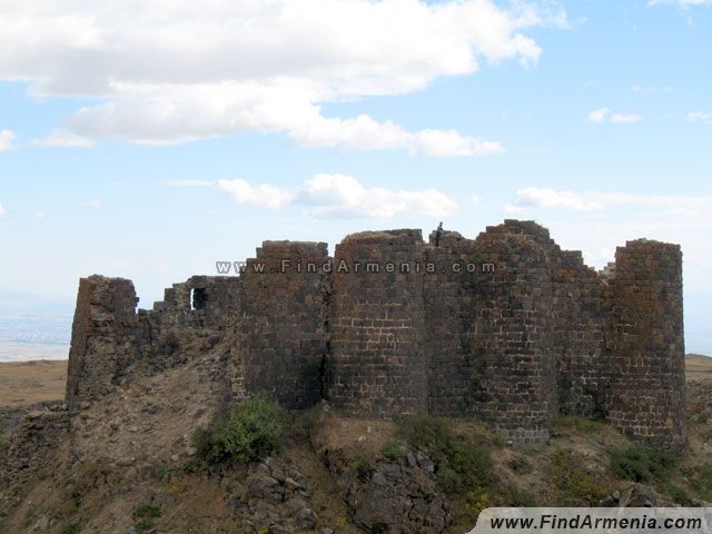
The Castle of Amberd
Its height is 2300 m above the sea level. The construction of the monastic complex of Saghmosavank was stopped in 1215 and it continued in 1290.
A lot of literature decorated with miniature painting was copied here. The beauty of the Aragats Mountain is completed with the Church of Mastara.

There are many frescos in the church of Mastara. The castles of Talin

and Aruch castles
are also known.
the material is taken from the http://www.findarmenia.com/arm/armenia/aragatzotn
The Region of Kotayk
The Region of Kotayk is located in the centre of the Republic of Armenia. This region is the only “inner” region of the RA. The centre of the region is the town of Hrazdan. The air temperature is +19 in summer and -9 in winter. One third of the region is surrounded by forests. Hrazdan is an industrial centre. It is rich in archeological buildings; particularly there are a lot of buildings of the 13th century. The most famous construction of the region is the Temple of Garni built during the Hellenic era.

The Temple of Garni was used by the king as a summer residence. The Temple is located on a beautiful triangle plateau. Alike the Hellenic style there is a bath-house near the Temple. You can feel the wonderful architectural style of the heating system from the ground. 5 km far from the Temple of Garni, in the gorge of Goght, in the rock dug there from ancient times there is located the monastic complex of Geghard.

In the old times it was called Ayrivank. The reason for changing the church’s name into Geghard was that the spear called geghard that had pierced the rib of Jesus Christ was being preserved in this church since 1260.
The Town of Tsaghadzor has become the pearl of the region. It is a small rest town. The Town of Tsaghadzor is famous for sports complexes. There are sports complexes necessary for summer and winter sports. The hill covered with snow attracts the lovers of winter sports. The skiers go up the Teghenis Mountain on the ropeway and from there can ski down the mountain.
the material is taken from the http://www.findarmenia.com/arm/armenia/kotayk
The Region of Gegharkunik

The Region of Gegharkunik is located in the Eastern part of Armenia, the height above the sea level is approximately 1500-1700 m. The territory of the Region of Gegharkunik is the largest. Its peculiarity is that 1/4 of its territory is covered with water. The highest peak is the mountain called Azhdahak (3589 m). The centre of the region is the town of Gavar.The Town of Sevan is an important industrial town located in the Eastern part of the Geghama Mountain. Lake Sevan
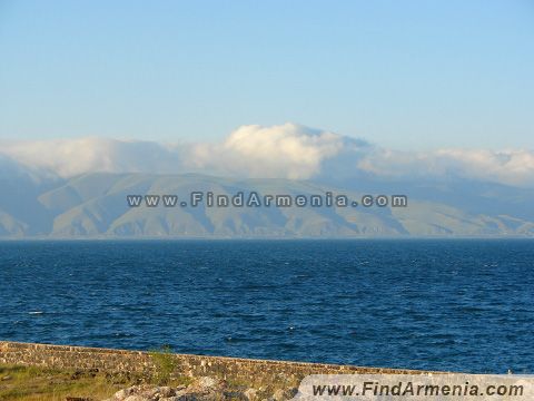
is located in the centre of the region and is the emerald of Armenia. Lake Sevan is nearly 1990 m high above the sea level. It was called Geghama Sea in the old times. Lake Sevan is the highest lake in the world which has fresh water. Ishkhan of Lake Sevan is the most famous of the region; the fish belongs to the salmon type of fish. This fish called ishkhan is the king of Lake Sevan. The Sevan peninsula together with the monastic complex is one of the secrets of nature. The Church of Sevan
is the sights of the Sevan peninsula. The monastic complex consists of three churches.
the material is taken from the http://www.findarmenia.com/arm/armenia/gegharkunik
The Region of Armavir

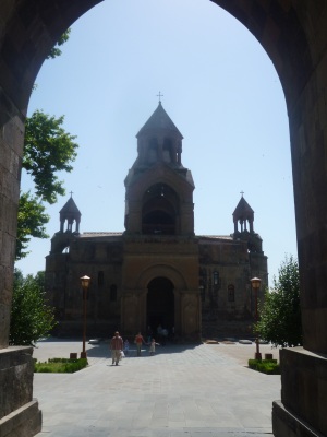
The Region of Armavir is located in the Southern part of the Region of Aragatsotn. This region was awarded the name of the old capital of Armenia – Armavir. The territory of the Region of Armavir is the smallest in the Republic of Armenia. Here is up to now the only road bridge built on the middle stream of the Araks River, which connects the Republic of Armenia with Turkey. The Region of Armavir is located between the Mountain Ararat and Aragats. The Region of Armavir is sunny and has a dry continental climate. Lake Metsamor is the only reservoir here. There are very many red insects here that are called vordan karmir. They make paints from those insects. Many ruins of castles, palaces and mausoleums are preserved here from prehistoric times. The five thousand years’ old (bronze era) smeltery excavated on the slope of Metsamor hill is a unique monument. The ruins of the Town of Argishtikhnili of the Araratyan Kingdom present a great historic value. During the long history of Armenia there have been 13 capitals and 4 of them were from this region: Armavir, Yervandashat,Bagaran,Vagharshapat. Vagharshapat (which is also known as Echmiatsin) is 15 minutes away by car from nowadays’ capital of Armenia Yerevan. It was the capital of Armenian Vagharsh king in 117-140 B.C. After adopting Christianity as a state religion, the Armenian king Trdat the Third destroyed the pagan temple of Vagarshapat and built the main church of Armenia there. According to the legend, Saint Grigor, who taught Christianity, has seen this place in his dream. Jesus Christ has come down from the sky, has shown the place with sceptre, where the church should be built. If we translate the word Echmiatsin, we’ll see that the word has the meaning of the place where the only child of the God has come down.
the material is taken from the http://www.findarmenia.com/arm/armenia/armavir
The Region of Ararat

This region is located in the Western part of Armenia and is in the South of Yerevan. The territory of the region has been part of the Vostan Province of the Ayrarat Province of the historic Armenia, which was known in the middle ages as the province of capitals. The capitals Artashat and Dvin are located here. Like an object of a legend or an idol the wonderful height of the Mountain Ararat, the depth of a gorge have a great influence on the Armenians. Another place that is famous in the Region of Ararat is the charming building of the monastic complex of Khor Virap, which is near the Ararat mountain. In the past it was a cellar called Khor Virap.

Before adopting Christianity as a state religion in 301 Saint Grigor has been imprisoned here for 13 years.
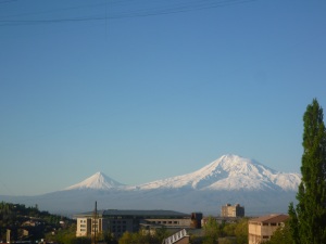
view of Mount Ararat from capital Yerevan
the material is taken from the http://www.findarmenia.com/arm/armenia/ararat
VAYOTS DZOR REGION

The Region of Vayots Dzor is located in the Southern part of Armenia. The Region of Vayots Dzor is actually a country of gulfs. There are forests in the 20% of the region. The slopes of mountains are everywhere cut by canyons and gulfs. The region is 1000-2300 m high above the sea level. The main water artery of Vayots Dzor is the Arpa River. The centre of this region is the Town of Eghegnadzor that is located on the bank of the Arpa River. In the Eastern part of the region there is the University of Gladzor built in the 13-14th centuries. This region is also famous of the health resort Town of Jermuk with its wonderful nature.
The Town of Jermuk
The Town of Jermuk is located in such a place, which has good climatic conditions: it is cool here in summer and mild in winter. In the Eastern part of the region there is the monastic complex of Noravank, which was built in the 12-13th centuries.
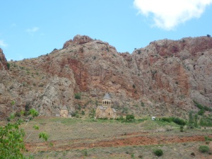
Noravank monastery complex
the 12-13th centuries in the eastern part of this region. This monastery complex is located in a ravine called Noravanq.
That canyon is rich with unique wild herbs and wild fruits and animals. Moreover, in this region, there is a botanical garden and a group of caves. In this region a lot of antiquities were found.
the material is taken from the http://www.findarmenia.com/arm/armenia/vayots-dzor
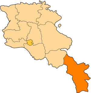
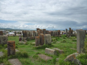
The Region of Syunik is the first according to its land territory. Formerly the ninth province of Mets Hayk was called Syunik. Formerly the transportational-geographical location of the Region of Syunik was very unfavorable. Nowadays by building a new bridge on the River of Araks the Region of Syunik gains a very important transitional significance. In Armenia the Region of Syunik is called the Southern gate of the Republic surrounded by Zangezour, Megri, and the plateau of Syunik. The highest point of the region from the sea level is the mountain Kaputjugh, which has 3904 m height, and the lowest point is located in the valley of the Araks River – 4380 m. The administrative centre of the region is the town of Kapan. Kapan is 750 m high above the sea level and is rich in copper and molybdenum mines. The Town of Goris is located on the bank of the river called Vararak. It is a town of health resort. You can see cave habitats in Goris. The stone observatory called Karahunj has a history of thousands of years B.C. Khndzoresk village like an amphitheater. The Tatev monastery which was built in 9-13 century, since 2010 was marked by the longest funicular railway in the world.
the material is taken from http://www.findarmenia.com/arm/armenia/syunik
translated from Armenian into English by M.Vardanyan


